Downloading, setup and running the GeoXact App is simple.
GeoXact App requires an Android phone and should work well including on inexpensive models. Download and install the GeoXact App. The default settings are suitable for most application, but can be easy changed.
The optimum installation location is the top on the passenger’s side, but can also be installed on the side window. It is recommended that the phone is set up so that the images are taken looking forward but also towards the passenger side of the road. Optimum is when the direction of travel is just inside the view. The slight sideways view increases the coverage of the features of interest that are best viewed at 45deg from the direction of travel. The phone needs to be in landscape mode as close as possible to the windscreen to increase the viewing range and reduce reflections.
GeoXact produce the X-mount which is a specially designed phone holder that can simplifies installation and optimized positioning. There are many mobile phone holders available on the market, that can maintain the phone in landscape mode and attaches to the windscreen. These typical are defined as being 360degree adjustable.
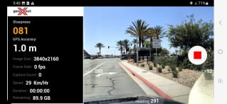
Running the app is simple. Just check the positioning and press record. The app will collect images at the required spacing and also provide details on parameters such as the image sharpness, rate of image capture and storage remaining. To reduce heat build up in hot climates there is a setting that will dim the display.
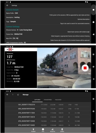
To publish or transfer enter the management panel. This will show a list of the collected sessions with simple actions.
Prior to publishing as an Oriented Imagery Layer it is necessary to enter the required ArcGIS Online credentials. Alternatively, an ArcGIS Online Token can be used or generated. The imagery can be uploaded as attachments in ArcGIS Online or alternatively in secured cloud storage.
Each session can create a separate Oriented Imagery Layer (set Name as Prefix_Date_Time), or each all sessions from the same day can be appended to a single Oriented Imagery Layer (set Name as Prefix_Date). Alternatively append all sessions to a single Oriented Imagery Layer based on the provided Name/Prefix. Note that multiple users can published to the same Oriented Imagery Layer so long as the layer has been shared with the different users. Publishing using a ‘Contributor’ role in ArcGIS Online is possible so long as the initial Oriented Imagery Layer is created by a user that has a ‘Creator’ role.
Publishing from the GeoXact app to ArcGIS Online also requires an ArcGIS Online License. Until the end of 2025 these can be obtained for no charge by registering the app. The registration process is built into the app and only requires providing an email address to which the license will be sent.
As an alternative to publishing the ArcGIS Online the imagery can be transferred to cloud storage or copied from the phone device to local storage. Transferring the data to local or cloud storage enables running GeoXact Pro which provides advanced capabilities for refining the accuracy of the image locations beyond that achieved by the real-time GPS positioning as well as features such as obfuscation of faces and feature extraction and positioning.